Impacts of snow cover and frozen soil in the Tibetan Plateau on summer precipitation in China
Rong Gao , HaiLing Zhong , WenJie Dong , ZhiGang Wei
1. Laboratory of Climate Studies, National Climate Center, China Meteorological Administration, Beijing 100081, China
2. State Key Laboratory of Earth Surface Processes and Ecology Resource, Beijing Normal University, Beijing 100875, China
3. Cold and Arid Regions Environmental & Engineering Research Institute, Chinese Academy of Sciences, Lanzhou, Gansu 730000, China
Impacts of snow cover and frozen soil in the Tibetan Plateau on summer precipitation in China
Rong Gao1*, HaiLing Zhong1, WenJie Dong2, ZhiGang Wei3
1. Laboratory of Climate Studies, National Climate Center, China Meteorological Administration, Beijing 100081, China
2. State Key Laboratory of Earth Surface Processes and Ecology Resource, Beijing Normal University, Beijing 100875, China
3. Cold and Arid Regions Environmental & Engineering Research Institute, Chinese Academy of Sciences, Lanzhou, Gansu 730000, China
This paper presents an analysis of the mechanisms and impacts of snow cover and frozen soil in the Tibetan Plateau on the summer precipitation in China, using RegCM3 version 3.1 model simulations. Comparisons of simulations vs. observations show that RegCM3 well captures these impacts. Results indicate that in a more-snow year with deep frozen soil there will be more precipitation in the Yangtze River Basin and central Northwest China, western Inner Mongolia, and Xinjiang, but less precipitation in Northeast China, North China, South China, and most of Southwest China. In a less-snow year with deep frozen soil, however,there will be more precipitation in Northeast China, North China, and southern South China, but less precipitation in the Yangtze River Basin and in northern South China. Such differences may be attributed to different combination patterns of melting snow and thawing frozen soil on the Plateau, which may change soil moisture as well as cause differences in energy absorption in the phase change processes of snow cover and frozen soil. These factors may produce more surface sensible heat in more-snow years when the frozen soil is deep than when the frozen soil is shallow. The higher surface sensible heat may lead to a stronger updraft over the Plateau, eventually contributing to a stronger South Asia High and West Pacific Subtropical High. Due to different values of the wind fields at 850 hPa, a convergence zone will form over the Yangtze River Basin, which may produce more summer precipitation in the basin area but less precipitation in North China and South China. However, because soil moisture depends on ice content, in less-snow years with deep frozen soil, the soil moisture will be higher. The combination of higher frozen soil moisture with latent heat absorption in the phase change process may generate less surface sensible heat and consequently a weaker updraft motion over the Plateau. As a result, both the South Asia High and the West Pacific Subtropical High will be weaker, hence causing more summer precipitation in northern China but less in southern China.
Tibetan Plateau; snow cover; frozen soil; summer precipitation
1. Introduction
Situated in the upper stream of the Chinese climate system, the Tibetan Plateau is the highest and the largest plateau in the world, and has important influences on the regional climate. As reported by Fenget al. (1998), the Plateau is a pilot region of climatic fluctuation. Due to its special landform, the Plateau is covered with the most snow and frozen soil in the mid-latitudes. Past observations at daily to monthly scales have confirmed that snow cover can lead to decreased near-surface temperature (Dewey, 1977). Cohen and Rind (1991) emphasized that the thermodynamic effects of snow cover are mainly characterized by high albedo, high emissivity, low thermal conductivity, and latent heat sink.Soil freezing or thawing processes can impact warming in summer and cooling in winter on land surfaces mainly by changing heat capacity and thermal conductivity. These processes can also change soil hydrological properties by preventing soil water infiltration, and can increase soil moisture in the active layer in a thawing phase (Poutouet al.,2004). Changes of snow cover and frozen soil have important impacts on surface heat sources of the Plateau, thus playing an important role in indicating precipitation trends,especially in the flood-prone season (June to August) in eastern China.
Chenet al. (2000) analyzed the mechanism of how the Plateau affected the intensity of summer monsoons in moreand less-snow years by using National Oceanic and Atmospheric Administration (NOAA) snow cover data. They proposed a model to simulate the impacts of winter snow cover of the Plateau on the Meiyu front (the persistent stationary front) in the Yangtze River Basin, and they concluded that more snow cover than normal on the Plateau would lead to abnormal atmospheric circulation in East Asia and engender a Category 3 Meiyu in the middle and lower reaches of the Yangtze River; less snow cover than normal would produce a Category 1 Meiyu front.
Weiet al. (2003) analyzed the influences of Plateau snow cover in more- and less-snow years on precipitation in China by using 10-year simulating results of the SAML-R42L9 model. They concluded that more snow on the Plateau causes more summer precipitation in the middle and lower reaches of the Yangtze River; the reverse is also true (less snow causes less summer precipitation). Zhu and Ding (2007) summarized research findings related to snow cover on the Plateau, suggesting that snow cover on the Plateau may reflect variations of heat sources there; this was positively correlated with summer precipitation in the middle and lower reaches of the Yangtze River. Wanget al.(2003) found that three high-correlation distribution belts existed from north to south related to the maximum frozen soil depth of the Plateau and summer precipitation in China.Gaoet al. (2005) concluded that the timing of frozen soil thawing on the Plateau was positively correlated with precipitation in the middle and lower reaches of the Yangtze River, but negatively correlated with the rest of China.
All of these studies focused on the effects of individual factors. However, snow cover and seasonal frozen soil of the Tibetan Plateau are important land-surface features that do not change in isolation. The thermal insulation of snow cover on soil can result in higher soil temperature under thick snow cover than where there is no such cover, and frozen soil can also prevent the infiltration of snow melt water into soil, instead forming surface runoff (Warrachet al., 2001).Therefore, isolated studies on impacts of snow cover or frozen soil on summer precipitation in China have some limitations; the combined influences of these factors must be addressed. Previous studies have proven that the predictability of summer precipitation (Gaoet al., 2010) could be improved by taking into account both snow cover and seasonal frozen soil on the Plateau. Here we report on the use of a new RegCM3 model version to simulate differences of summer precipitation in China due to the freezing depth difference in both more- and less-snow years on the Plateau,and we analyze the various mechanisms that cause differences in frozen soil in more- and less-snow years.
2. Model description and experiment design
The regional climate model RegCM3 version 3.1 (Nellieet al., 2006) was developed by the International Centre of Theoretical Physics Weather/Climate Physics Group(PWC/ICTP), with new physical parameterization schemes added based on RegCM2. Baoet al. (2006), Liuet al.(2008), and Zhanget al. (2007) have proved that RegCM3 has good simulation capability for East Asia, and Zhanget al.(2005) and Quet al. (2009) demonstrated that RegCM3 has similar good performance for the Plateau region as well.
In Gaoet al.’s (2008, 2010) research on variation sequences of the Tibetan Plateau snow cover and seasonal frozen soil, 10 more-snow years, 10 less-snow years, 10 deep-frozen-soil years, and 10 shallow-frozen-soil years were selected for comparisons. They found that the abnormal years of snow cover or frozen soil is largely different in the Tibetan Plateau. The years with more snow and deep frozen soil were 1968, 1978, and 1983; the years with more snow and shallow frozen soil were 1990 and 1995; the years with less snow and deep frozen soil were 1967, 1971, and 1984; and the only year with less snow and shallow frozen soil was 1999. Gaoet al.’s investigations of precipitation differences as related to different frozen soil depths in the more- and less-snow years showed that abnormal precipitations due to differences in frozen depths were similar in distribution (figure omitted).Therefore, for our analysis we selected the years 1983 (with more snow and deep frozen soil), 1990 (with more snow and shallow frozen soil), 1971 (with less snow and deep frozen soil), and 1999 (with less snow and shallow frozen soil) for simulations to study the different impacts of various combination patterns of the Plateau snow cover and frozen soil on the summer precipitation in China.
In RegCM3 version 3.1 the central point was set at 100°E and 35°N, the total number of its grid points was 121×101, the horizontal resolution was set at 60 km, and there were 18 vertical layers, with the top level at 10 hPa. Its integration step length was set at 75 s. We used National Centers for Environmental Prediction (NCEP; Washington D.C.) reanalysis (four times/day; 2.5°×2.5°) for atmospheric forcing. Global Land Cover Characterization (GLCC) data derived from United States Coast Guard (USGS) were used for land cover, and NOAA Optimum Interpolation Sea Surface Temperature (OISST) data were used for sea temperature. The boundary buffer zone in the model (10 grid points)adopted a boundary index relaxation scheme and the Grell scheme was used for cumulus convective parameterization.For the above selected four years, the modeling started on September 1 of the previous year and the integration ended on August 31 of the current year. This paper analyzes the results from June 1 to August 31 in the selected years only.In order to reduce abnormal model behavior caused by different initial values, the data from July 1 and August 1 of the previous year were also used as initial values for modeling.The results of the three simulated initial values were averaged to represent the final model output.
3. Results analysis
3.1. Differences in summer precipitation modeling
From the percentages of simulated summer precipitation differences in the years with deep and shallow frozen soil(Figure 1), during years with more snow and deep frozen soil the precipitation was increased by 20%-60% in the Yangtze River Basin and central Northwest China compared with the shallow frozen soil years. Figure 1a shows that precipitation was generally decreased by 20%-40% in most of Northeast China, North China, South China, and Southwest China compared to the years with more snow and shallow frozen soil. When frozen soil was deep in the less-snow years, the precipitation was increased by 20%-60% in Northeast China, North China, and southern Southwest China, western Inner Mongolia, and western Xinjiang, while the precipitation was decreased by 20%-40% in the Yangtze River Basin, northern South China, and most of Northwest China (Figure 1b).
This clearly differed from the precipitation variation related to the frozen soil depth in the more-snow years. The distribution of simulated precipitation anomalies (in percentages) was basically consistent with the observations,except for some value differences, especially in the northwestern region where the precipitation was usually less(Figure 1c, 1d). When there was more snow, the simulated precipitation differences between deep frozen soil and shallow frozen soil were lower than observations in North China.However, the simulated precipitation differences in central Northwest China were greater than the observations. In the less-snow years with deep frozen soil, both the range and magnitude of simulated "less precipitation" to the south of the Yangtze River were less than observations. The overestimated "more precipitation" differed significantly from the observations in the south of Southwest China, but the simulated "more precipitation" in north and northeast of China from the model was close to observations.
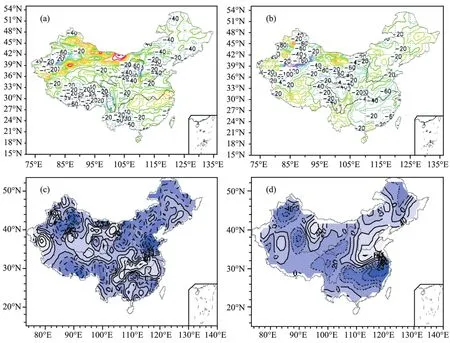
Figure 1 Simulated (a, b) and observed (c, d) summer precipitation in a more-snow year (a, c) and a less-snow year (b, d)(the percentages of precipitation of deep frozen soil year minus shallow frozen soil year, units: %)
The model errors may be attributed to the relatively stable general atmospheric circulation over East Asia in the more-snow years; therefore, the impact of differences in frozen depth could be easily captured. In contrast, the East Asia atmospheric circulation was less stable in the less-snow years; especially in 1999, the model output was not good enough and this led to a large error compared with the observed precipitation.
3.2. Analysis of the mechanisms of precipitation anomaliesBased on Weiet al. (2002), the snow cover in the Tibetan Plateau mostly appears from October to May, and there is little of that in June. The seasonal thawing time of frozen soil generally occurs in early May at the earliest and the end of June or early July at the latest (Gaoet al., 2002).The melting of snow cover and thawing of frozen soil will absorb the latent heat of phase transition that will change soil moisture, and then surface heat source in the Plateau and general atmospheric circulation over East Asia will change. From the differences in the simulated summer surface soil moisture between deep and shallow frozen soil years (Figure 2), it can be seen that the surface soil moisture on most of the Plateau in more-snow years is lower than that in less-snow years, except for higher surface soil moisture in the western Himalayas and Kunlun Mountains (Figure 2a). In less-snow years with deep frozen soil, the surface soil moisture in the southern and central Plateau is higher than normal, but it is lower in eastern Qinghai, western Himalayas, and Kunlun Mountains (Figure 2b). Changes in soil moisture maybe attributed to different combinations of melting snow and thawing frozen soil.
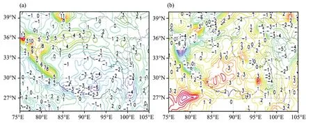
Figure 2 Simulated differences of summer soil moisture in a more-snow year (a) and a less-snow year (b)(the difference of soil moisture of deep frozen soil year minus shallow frozen soil year, unit: g)
Differences in soil moisture inevitably change the energy exchange between the Plateau surface and the atmosphere. Figure 3 shows changes of the summer surface sensible heat flux resulting from differences in deep frozen soil and shallow frozen soil. The figure shows that in a more-snow year with deep frozen soil the sensible heat is stronger over the southern and central Plateau in summer, but is weaker in eastern Qinghai, western Himalayas,and Kunlun Mountains (Figure 3a). In less-snow years with deep frozen soil, the sensible heat over most of the Plateau is weaker in summer (Figure 3b). Such contrast is mainly due to differences in surface soil moisture and the quantity of latent heat absorbed in thawing phase of the frozen soil.
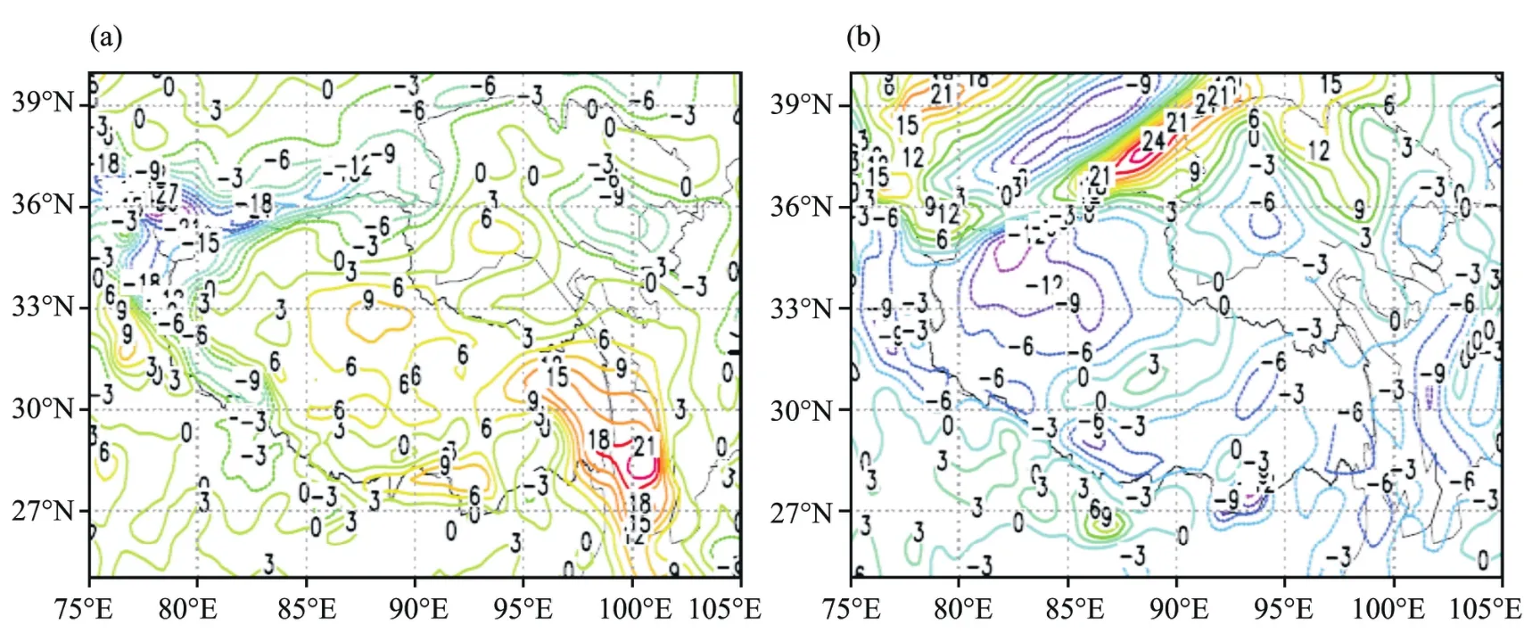
Figure 3 Simulated difference of summer surface sensible heat in a more-snow year (a) and a less-snow year (b)(the difference of sensible heat of deep frozen soil year minus shallow frozen soil year, units: W/m2)
Previous findings show that variations in surface heat sources of the Plateau will inevitably change the general atmospheric circulation over East Asia. Differences in frozen soil depth on the Plateau may change the surface heat sources, leading to changes in general atmospheric circulation over the region. Figure 4 shows the variation of the South Asian High due to the frozen depth in more-snow and less-snow years. As shown in the figure, in more-snow years with deep frozen soil, sensible heat is relatively stronger on the Plateau surface, and the South Asia High is also apparently stronger than in the shallow frozen soil years, with its 12,500-gpm line extending east up to 120°E, covering almost all areas in south of the Yangtze River. In comparison,this line only reaches to about 105°E at most in shallow frozen soil years (Figure 4a). The general atmospheric circulation variation as a result of differences in frozen depth in less-snow years is just the opposite in more-snow years.With deep frozen soil, the 12,480-gpm contour is much smaller and tends to protrude 10° farther west and 5° farther north compared to that in years with shallow frozen soil(Figure 4b).
Changes of the South Asian High may change the downdraft flow over the West Pacific Subtropical High,consequently changing the high-pressure system itself. As shown in Figure 5, in more-snow years with deep frozen soil,the South Asia High is relatively stronger, making a stronger downdraft flow over the West Pacific, eventually leading to stronger Subtropical High with its ridge line extending slightly farther south. However, in a shallow frozen soil year the South Asian High is relatively weaker with its ridge line protruding farther north (Figure 5a). Subtropical High variation related to shallow frozen soil in less-snow years is opposite to that in more-snow years. In a deep frozen soil year the Subtropical High tends to be weaker with its ridge line extending farther to the north, but with shallow frozen soil on the Plateau the Subtropical High is comparatively stronger with its ridge line located farther south (Figure 5b).
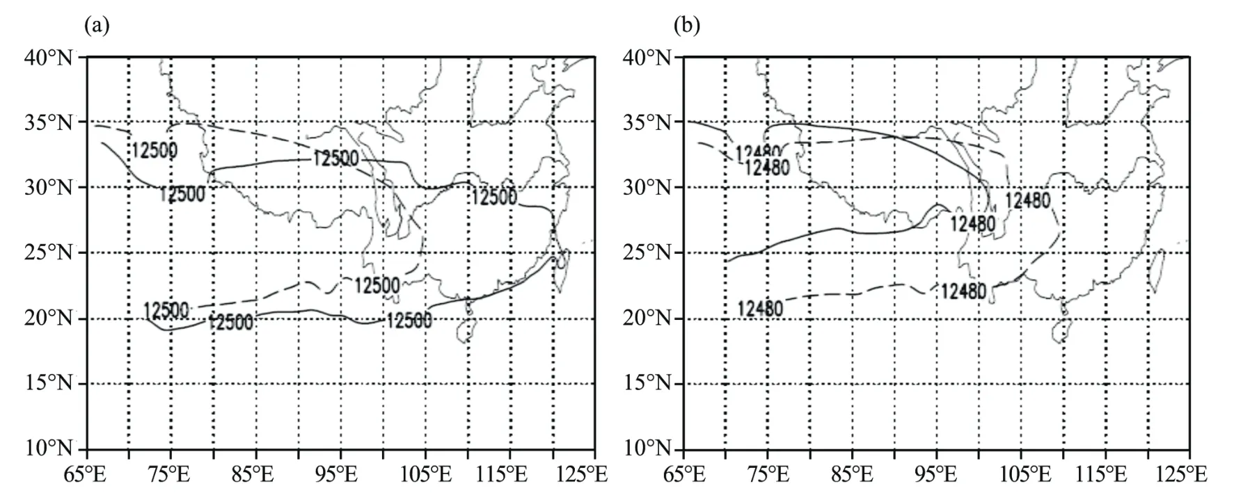
Figure 4 The simulated differences of the South Asia High between a more-snow year (a) and a less-snow year (b) in summer(unit: gpm; solid line: deep frozen soil year; dashed line: shallow frozen soil year)

Figure 5 Simulated differences of the Subtropical High position between a more-snow year (a) and a less-snow year (b) in summer(unit: gpm; solid line: deep frozen soil year; dashed line: shallow frozen soil year)
Changes in intensity and location of the Subtropical High over the West Pacific may change the atmospheric stream field, eventually making a difference in water vapor transport. From the 850 hPa charts showing stream field differences between deep and shallow frozen soils in a more-snow year (Figure 6a), it can be seen that a northbound flow anomaly appears south of the Yangtze River in the deep frozen soil year, and a southward flow anomaly is seen in north of the river, compared with the shallow frozen soil year. Both anomalies generated an anomalous shear of airflow near the river, which, together with more water vapor from southern China, led to more precipitation along the Yangtze River Basin and less precipitation over southern and northern China. In the deep frozen soil but less-snow year, an anti-cyclonic anomalous circulation appeared centering around the lower reaches of the Yangtze River; the easterly wind anomaly dominated south of the river, and the southerly wind anomaly dominated north of the river, causing less precipitation over the Yangtze River Basin and southern China in the deep frozen soil year, and more precipitation over northern China.
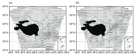
Figure 6 Simulated stream field differences between a more-snow year (a) and a less-snow year (b) at 850 hPa in summer(the difference of stream field of deep frozen soil year minus shallow frozen soil year; unit: m/s)
4. Conclusions
The above analysis shows that the RegCM3 version 3.1 model is capable of capturing the impacts of different frozen soil depths on the Tibetan Plateau, under different snow cover conditions, on summer precipitation in China.The model outputs suggest that in a more-snow year with deep frozen soil there will be more precipitation over the Yangtze River Basin and in central Northwest China, but less precipitation over Northeast China, North China,South China, and most of Southwest China. In a less-snow year with deep frozen soil, there will be more precipitation over Northeast China, North China, and southern Southwest China, western Inner Mongolia, and western Xinjiang,and less precipitation over the Yangtze River Basin and in northern South China. The causes of these differences may be the following:
(1) Different combinations of snow melting and frozen soil thawing have different impacts on the soil moisture of the Plateau. Together with different levels of heat absorption in the phase change process, these lead to higher surface sensible heat and stronger updraft motion, eventually enhancing the South Asia High and the West Pacific Subtropical High.
(2) The horizontal wind field differences at 850 hPa generate a convergence zone over the Yangtze River Basin,which causes more precipitation in the basin but less precipitation in North China and South China.
(3) The differences in soil moisture in less-snow years mainly depend on the water content in the frozen soil.Therefore, in a deep frozen soil year the higher soil moisture and latent heat absorption in the phase change lead to lower surface sensible heat on the Plateau, and consequently a weaker South Asia High and West Pacific Subtropical High, plus a clear northerly wind anomaly occurring to the north of the Yangtze River. All of these factors lead to more precipitation in northern China but less in southern China.
The authors are very thankful to reviewers for proposing good suggestions and improving the English in this manuscript. This research is supported by the National Key Basic Research Program (No. 2007CB411505) and the National Natural Science Foundation (No. 40705031).
Bao Y, Lu SH, Lu DR, Hou RQ, 2006. Application of regional climate model (RegCM3) in Northwest China I: Simulation of an arid extreme event.Journal of Glaciology and Geocryology, 28(2): 164-174.
Chen QJ, Gao B, Zhang Q, 2000. Studies on relation of snow cover over the Tibetan Plateau in winter to the winter-summer monsoon change.Chinese Journal of Atmospheric Sciences, 24(2): 477-491.
Cohen J, Rind D, 1991. The effect of snow cover on the climate. Journal of Climate, 4: 689-706.
Dewey KF, 1977. Daily maximum and minimum temperature forecasts and the influence of snow cover. Monthly Weather Review, 105: 1594-1597.
Feng S, Tang MC, Wang DM, 1998. New evidence for the Qinghai-Xizang(Tibet) Plateau as a pilot region of climatic fluctuation in China. Chinese Science Bulletin, 43(6): 633-636.
Gao R, Wei ZG, Dong WJ, 2002. Interannual variation of the beginning date and the ending date of soil freezing in the Tibetan Plateau. Journal of Glaciology and Geocryology, 25(1): 49-51.
Gao R, Wei ZG, Dong WJ, 2008. The character of temporal and spatial distribution of seasonal frozen soil in Tibetan Plateau. Journal of Glaciology and Geocryology, 30(5): 740-744.
Gao R, Wei ZG, Dong WJ, Zhong HL, 2005. Impact of the anomalous thawing in the Tibetan Plateau on summer precipitation in China and its mechanism. Advances in Atmospheric Sciences, 22(2): 238-245.
Gao R, Zhong HL, Dong WJ, Wei ZG, 2010. The catastrophe character of snow and frozen soil in Tibetan Plateau and its impact on summer precipitation of China. Journal of Glaciology and Geocryology, 32(3):469-474.
Liu YQ, Fan GZ, Zhou DW, Hua W, Li XM, Huang XL, Zhang YH, Wang YL, 2008. Numerical simulation of summer precipitation in China by using a regional climate model (RegCM3). Journal of Chengdu University of Information Technology, 23(4): 442-447.
Nellie E, Bi X, Giorgi F, Badrinath N, Jeremy P, Fabien S, Sara R, Ashraf Z,2006. RegCM Version 3.1 User’s Guide, Trieste, PWCG Abdus Salam ICTP.
Poutou E, Krinner G, Genthon C, Noblet-Docoudre N, 2004. Role of soil freezing in future boreal climate change. Climate Dynamics, 23:621-639.
Qu P, Yang MX, Guo DL, Chen CX, 2009. Simulation of summer air temperature and precipitation over Tibetan Plateau with regional climate model (RegCM3). Plateau Meteorology, 28(4): 738-744.
Wang CH, Dong WJ, Wei ZG, 2003. Study on relationship between the frozen-thaw process in Qinghhai-Xizang Plateau and circulation in East-Asia. Chinese Journal of Geophysics, 46(3): 309-315.
Warrach K, Mengelkamp HT, Raschke E, 2001. Treatment of frozen soil and snow cover in the land surface model SEWAB. Theoretical and Applied Climatology, 69: 23-37.
Wei ZG, Chen W, Huang RH, 2003. Numerical simulation of the influence of the Tibetan Plateau winter-spring snow anomalies on the summer precipitation in China. Plateau and Mountain Meteorology Research, 28(1):1-7.
Wei ZG, Huang RH, Chen W, Dong WJ, 2002. Spatial distributions and interdecadal variations of the snow at the Tibetan Plateau weather stations. Chinese Journal of Atmospheric Sciences, 26(4): 496-508.
Zhang DF, Gao XJ, Bai HZ, Li DL, 2005. Simulation of climate over Qinghai-Xizang Plateau utilizing RegCM3. Plateau Meteorology, 24(5):714-720.
Zhang DF, Ouyang LC, Gao XJ, Zhao ZC, Pal J, Giorgi F, 2007. Simulation of the atmospheric circulation over East Asia and climate in China by RegCM3. Journal of Tropical Meteorology, 23(5): 444-452.
Zhu YX, Ding YH, 2007. Influences of snow cover over Tibetan Plateau on weather and climate: Advances and problems. Meteorological Science and Technology, 35(1): 1-8.
10.3724/SP.J.1226.2011.00491
*Correspondence to: Dr. Rong Gao, senior engineer of National Climate Center, China Meteorological Administration, Beijing 100081, China. Tel: +86-10-68406107; Email: gaor@cma.gov.cn
10 June 2011 Accepted: 28 August 2011
 Sciences in Cold and Arid Regions2011年6期
- Sciences in Cold and Arid Regions的其它文章
- Analysis on the temporal-spatial distribution character and effect factors of PM10 in the hinterland of Taklimakan Desert and surrounding area
- Variability of atmospheric freezing level height derived from radiosonde data in China during 1958-2005 and its impact to cryosphere changes
- Incident analyses of frost heaving failure of municipal underground gas pipelines in cold regions of northern China
- Simulation and analysis of river runoff in typical cold regions
- Characteristics of dynamic strain and strength of frozen silt under long-term dynamic loading
- Climatic changes have led to significant expansion of endorheic lakes in Xizang (Tibet) since 1995
