Spatial distribution of cutaneous anthrax in western Iran from 2009 to 2016:Geographic information system mapping for predicting risk of anthrax outbreaks
Ebrahim Ghaderi, Behzad Mohsenpour, Ghobad Moradi, Mohammad Karimi, Fatemeh Najafi, Seiran Nili,Samaneh Rouhi
1Zoonoses Research Center, Research Institute for Health Development, Kurdistan University of Medical Sciences, Sanandaj, Iran
2Social Determinants of Health Research Center, Research Institute for Health Development, Kurdistan University of Medical Sciences, Sanandaj, Iran
3Student Research Committee, Kurdistan University of Medical, Sciences, Sanandaj, Iran
4Department of Epidemiology, School of Public Health,Kerman University of Medical Sciences, Kerman, Iran
5Medical Microbiology Research Center, Qazvin University of Medical Sciences, Qazvin, Iran
ABSTRACT
Objective: To explore the spatial accumulation of diseases and their aggravating factors are essential in all public health. This study attempts to use geographic information system (GIS) to provide more information about the incidence and future of anthrax.
Methods: Patients were diagnosed with anthrax in Kurdistan Province from 2009 to 2016. Data was then exported into ArcGIS software version 9 and the required layers for years and areas were added.Final map for each year was drawn up, pointing out the hot spots and predicting its future pattern.
Results: Most cases were reported in females (57 cases, 54.80 %),and the lower body limbs were most affected (63 cases, 60.57%).The highest numbers of incidences were related to the cities of Marivan, Saqez and Divandareh, with more concentration in the central parts of the province, rather than borderline areas. The highest percentage of the probable incidence of the disease was in Sanandaj (57.74%) with a potential susceptible area of 1 729.12 km2 and then in Saqez (54.36%) with a potential area of 2 422.4 km2.
Conclusions: A vast area of Kurdistan Province is high risk for new cases of anthrax. Therefore, it is important to scale up the surveillance system in the province.
KEYWORDS: Spatial distribution; Cutaneous anthrax; Geographic Information System
1. Introduction
Epidemiology uses the analysis of place, person and time, and accordingly, helps to describe the existing conditions. Analysis of time and place in the distribution of diseases is difficult with traditional methods[1]. Today, using the geographic information system (GIS) to determine the patterns of disease distribution, the identification of high-risk areas and the association of diseases with environmental conditionshas becomean appropriate tool for management of health problems and solving analysis issues related to time and place[2-4]. Mapping diseases, using GIS, can reveal high-risk areas, the relationship between diseases and heights,vegetation, plains, etc[5,6]. Anthrax caused by Bacillus (B.) anthracis bacteria and is endemic disease in some parts of Iran. This disease primarily affects herbivorous animals, but all mammals are more or less susceptible to this disease. In humans, the most common form of the disease is a mild cutaneous infection that causes the necrotic black ulcer. Anthraxspores can remain in the soil for decades in their natural cycle of life, and during this period, spores can potentially cause infection in herbivorous animals. But in general, the risk of direct infection is not considered for humans until heavy rains or other destructive events cause them to come into surface of the soil,thereby causing herbivorous animals to be infected. Spores from carcasses that have been buried for several decades can also expose live animals to infection. Therefore, the location of the disease can help the health system to find contaminated areas. Different research showed distribution of B. anthracis in world areas[7-10]. In a research,it was estimated 1.83 billion people live in regions of anthrax risk in world. Also this study showed globally a total of 63.8 million poor livestock keepers and 1.1 billion livestock live within vulnerable regions[7]. Also a study reported that 35 different genotypes of B. anthracis were identified[11]. A study predicted landscape for anthrax high risk was 32.2%. In this study, 75% and ~64% of AMOEBA clusters and Gi* clusters corresponded to predicted high risk, respectively[12]. Also in another research, temporal and spatial geographic mapping of anthrax showed that, the high-risk areas are increasing and rural areas were high risk for anthrax majority outbreaks (83.7%)[13]. Kurdistan Province, located in western Iran,is one of the areas with a high incidence of anthrax in the country,and there are a number of human cases of anthrax in the province each year. Therefore, mapping the incidence of anthrax,and using the GIS tool to determine the high risk areas, can help to outline the timing and development of the disease and predict its likely trend in the future. Therefore, this study aims to determine the geographical distribution and to describe the characteristics of cutaneous anthrax in Kurdistan Province from 2009 to 2016.
2. Materials and methods
2.1. Study design
This cross-sectional study was performed on data on the surveillance system of anthrax in Kurdistan Province (West of Iran).Based on this system, suspected cases of anthrax are reported to health centers by physicians and health workers, where all data is ultimately shared with the surveillance group of communicable diseases in the same province. Anthrax cases are diagnosed according to the definitions of the World Health Organization(WHO). First, patients are examined with suspicion of anthrax, and certain cases are determined according to the following definitions.
2.2. Definitions of the surveillance system for cutaneous anthrax
Suspectcase: There are clinical signs consistent with cutaneous anthrax (itchy skin papules in open skin that become vesicles within one or two days) with an epidemiological link with suspected or definite cases of animal anthrax or contaminated animal products.Probablecase:Suspicious case with incidence of a black necrotic center following the vesicle stage with painless edema and a certain range around the lesion. Confirmed case: a suspect or probable case with a definite diagnostic criterion (separating the anthrax bacillus from the vesicle, positive smear or isolating it in the culture medium).
The surveillance system data was reviewed by one person and the patients with cutaneous anthrax were diagnosed. Then supplementary information was extracted from completed questionnaires for patients.
2.3. Study setting
Kurdistan Province with an area of 28 235 km2covers about 7.1%of the country. The province isin the west of Iran, bordering the neighboring Iraq, locates between 34 degrees 44 minutes to 36 degrees 30 minutes’ north latitude, and 45 degrees 31 to 48 degrees and 16 minutes’ east longitude from the Greenwich meridian(topographic maps 1: 25 000). Figure 1 shows the location of the study area in Iran. Kurdistan Province is bound by Zanjan Province to the north and Iraq to the west. The average annual rainfall in the province is 505 mm, the average annual temperature (center of the province) is 13.6 ℃, the highest point of the province is 3 262 m(Badrmountain in Qorveh) and the lowest point of the province is 750 m (outlet of the Chervon basin).
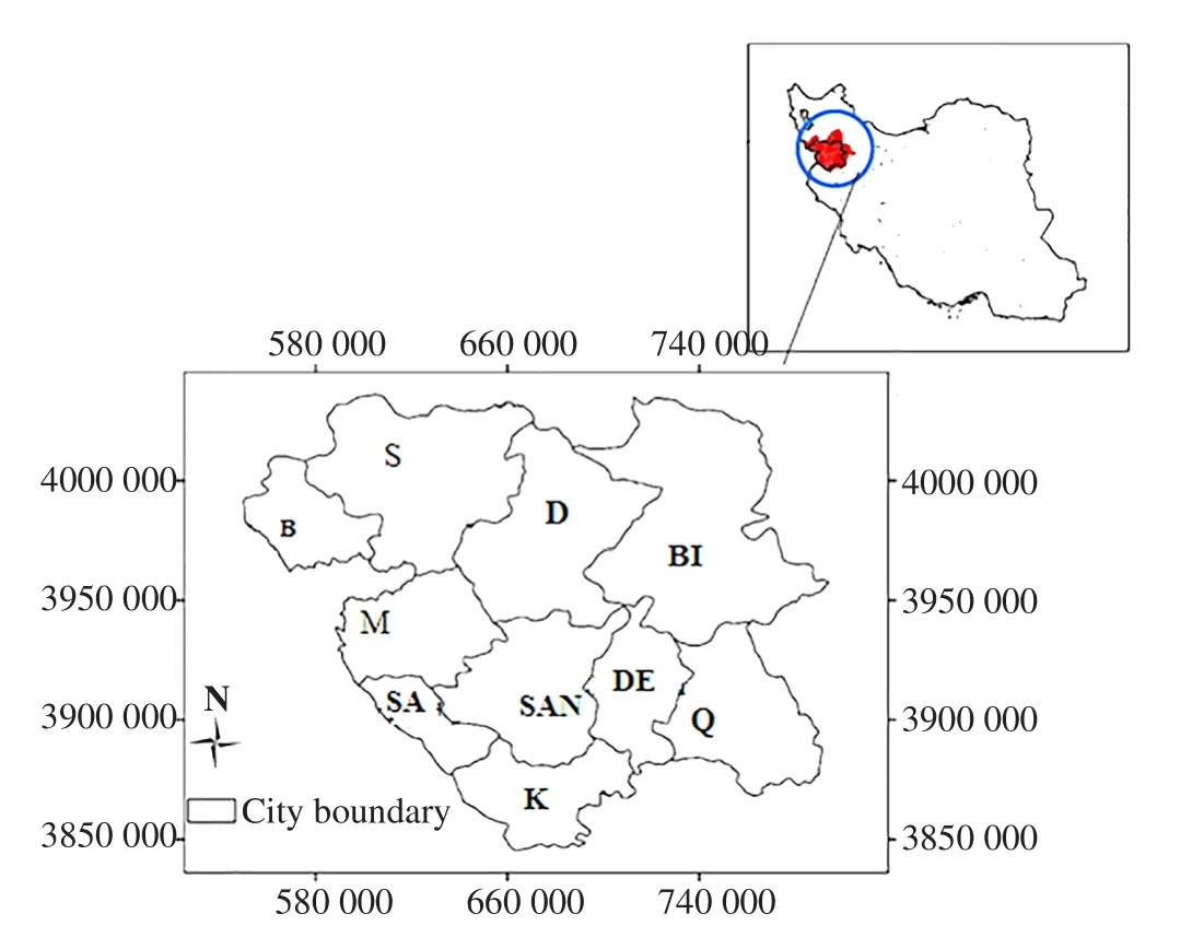
Figure 1. Location of the studied area cutaneous anthrax in western Iran (B;Baneh, S; Saqez, D; Divandareh, BI; Bijar, M; Marivan, SA; Sarvabad, SAN;Sanandaj, DE; Dehgolan, Q; Qorveh, K; Kamyaran, the numbers represent the km2 of area).
2.4. Data analysis
For the initial description, the extracted data was entered in the SPSS software version 19. Then the distribution of frequencies and percentages was calculated. Data on rural areas and their geographical coordinates were also included in the Excel file, and was then exported intothe ArcGIS 9 software. The necessary layers as years and areas were added. Finally, the final map for each year was drawn up by pointing out hot spots and predicting its future pattern. The map of incidence rate in each city was obtained by dividing the number of anthrax patients into the area measurement of the city. The raster map was drawn based on the average number of incidences in the 8-year statistical period. Subsequently, assuming that the risk of developing the disease decreases as we move away from the center of incidence of the disease, the map of disease incidence risk was prepared, based on the distance from the center of disease incidence. The mapwas classified into 5 categories of “Very high” (10 km), “High” (20 km), “Medium” (30 km), “Low” (40 km) and “Very low” (more than 40 km). Spatial analysis was used to study the geographic distribution of anthrax. In this research we investigated the inverse distance-weighted interpolation, information distribution situation.
3. Results
3.1. Distribution of cutaneous anthrax according to different cities and variables
In 56 villages in Kurdistan Province, all of 104 patients with cutaneous anthrax were studied. The highest number of anthrax cases in 2012 and 2015 was 22 cases (21.15%) and 21 cases(20.19%), respectively, and the lowest in 2010 and 2011 was 6 cases (5.76%) for each year. According to the same map, the cities of Marivan, Saqez and Divandareh have the highest incidence of anthrax. Most cases of anthrax were found in Marivan city(28 cases, 26.92%) and the least cases were in Kamyaran city (1 case, 0.96%) (Figure 2 and 3). Moreover, the majority of cases were reported in the month of Tir (22 June-22 July) with 35 cases(33.65%) and the least cases were reported in Dey (22 December-20 January) and Esfand (20 February-20 March) with zero cases. Most cases of anthrax were reported in female (57 cases, 54.80%). The most frequent cases of anthrax were reported in housewives with 56 cases (53.84%) and the lowest among slaughter house worker, army conscript, children, and employees (0.96%). The most commonly reported cases of anthrax were found in humans who handled the carcasses of animals (54 cases, 51.92%). The majority of anthrax was found in individuals with close contact with animals (65 cases,62.50%). Most of anthrax cases were reported in the lower body limbs (63 cases, 60.57%) and the least cases were reported in the face and neck (6 cases, 5.76%) (Table 1). Outbreak risk of anthrax based on distance from the onset of the cases in Bijar, Qorveh and Kamyaran was higher than other cities (Figure 4).
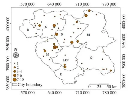
Figure 2. Distribution of anthrax by number of affected people in the 8-year period (B: Baneh, S: Saqez, D: Divandareh, BI: Bijar, M: Marivan, SAN:Sanandaj, DE: Dehgolan, Q: Qorveh, K: Kamyaran, the numbers represent the km2 of area).
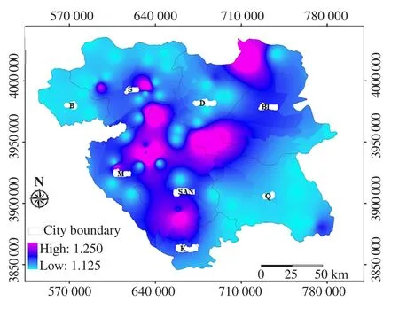
Figure 3. Probability rate of incidence of anthrax, by average number of cases in the 8-year period [(B: Baneh, S: Saqez, D: Divandareh, BI: Bijar, M: Marivan,SAN: Sanandaj, Q: Qorveh, K: Kamyaran, the numbers represent the km2 of area, higher and lower area distribution of anthrax are showed with high (km2)and low (km2) in map, respectively].
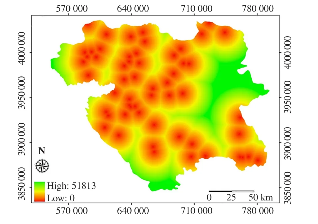
Figure 4. Outbreak risk of anthrax based on distance from the onset of the cases[the numbers represent the km2 of area, higher and lower area distance from the onset of anthrax cases are showed with high (km2) and low (km2) in map,respectively].

Table 1. Distribution of cutaneous anthrax in western Iran according to different variables.
3.2. Distribution map of anthrax based on year
Below are distribution maps of anthrax during the years 2009 to 2016. Regarding the number of anthrax cases, the disease had a fluctuating trend (increase-decrease) during the study period and most of the cases (22 cases) occurred in 2012. In general, the largest number and distribution of of the disease occurred in the cities of Marivan, Saqez and Divandareh, which could be due to more livestock in these areas. According to the maps, the disease has no particular development trend and has been updated in some cities in each year (Figure 5).
3.3. Prediction of anthrax incidence
Based on data of study period, the points with more average and frequency of anthrax cases were identified. Then, a map of altitude, land use, distance from rivers and contour lines was used to prepare the prediction map for susceptible areas of anthrax.The areas with the outbreak of the disease (considering areas with highest incidence rates) were assigned Code 1, the rest were marked with Code 0. Generally, the process of creating the zoning map of disease-prone areas involves the preparation and composition of a set of maps or layers that identify areas that are likely to develop a disease. Table 2 shows the standardization of the parameters and their scoring. After mapping the key parameters, a raster map of(50×50) pixels was prepared. Finally, the values were classified into two domains according to Table 2, and each pixel was assigned the appropriate numerical value using the standard table. Percentage of regions prone to incidence of anthrax, by area measurement were included; Sanandaj: 57.74% (Area of anthrax-prone region: 1729.12 square kilometer (km2), City area: 2 994.4 km2); Saqez: 54.36%(Area of anthrax-prone region: 2 422.4 km2, City area: 4 455.6 km2);Divandareh: 49.80% (Area of anthrax-prone region: 1 980.2 km2, City area: 3 974.6 km2); Kamyaran: 47.90% (Area of anthrax-prone region:977.6 km2, City area: 2 040.7 km2); Marivan: 29.70% (Area of anthraxprone region: 1 004.5 km2, City area: 3 384.2 km2); Baneh: 24.40%(Area of anthrax-prone region: 376.2 km2, City area: 1 542.7 km2) and Qorveh: 17.70% (Area of anthrax-prone region: 833.04 km2, City area:4 695.9 km2). Then the maps of susceptible areas of the disease was prepared, using product algorithm computation in Arc GIS software(Figure 6).
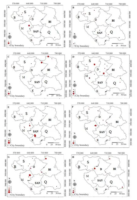
Figure 5. Distribution map of anthrax during the study year’s period (A: 2009, B: 2010, C: 2011, D: 2012, E: 2013, F: 2014, G: 2015, H: 2016; (B: Baneh, S:Saqez, D: Divandareh, BI: Bijar, M: Marivan, SAN: Sanandaj, Q: Qorveh, K: Kamyaran, the numbers represent the km2 of area).
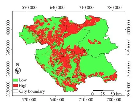
Figure 6. Map of probable areas of incidence of anthrax in Kurdistan Province (B: Baneh, S: Saqez, D: Divandareh, BI: Bijar, M: Marivan, SAN:Sanandaj, Q: Qorveh, K: Kamyaran, the numbers represent the km2 of area).
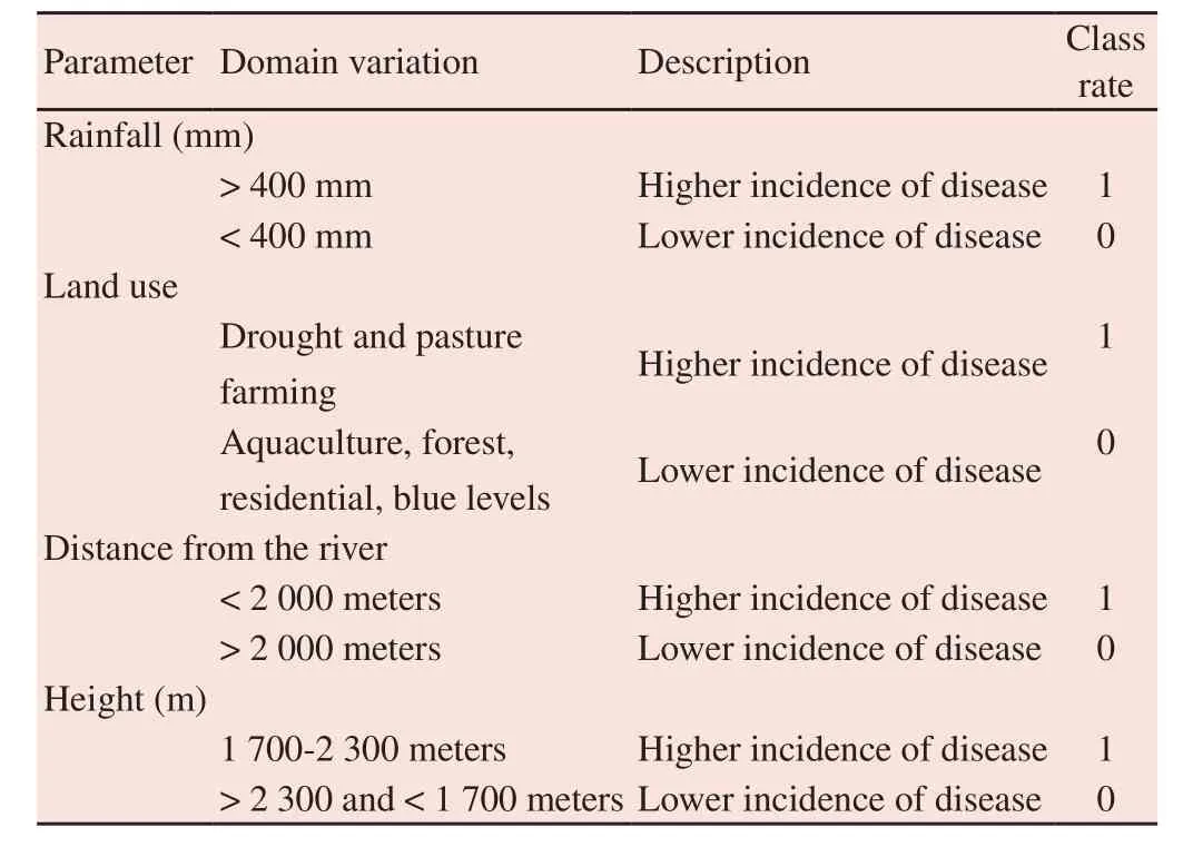
Table 2. Classification of the parameters and their scoring in the case of anthrax.
4. Discussion
In the livestock, anthrax is accompanied by a high mortality.Humans can be infected through accidental contact with contaminated livestock,their skin, wool and other products. In developed countries, imported animal products from endemic countries raise the risk of transmission. Despite the overall decrease in the number of cases of worldwide outbreaks, resulting in a reduction in the number of human cases, anthrax is among those diseases that are less commonly diagnosed and reported[14,15].According to the results of the present study, the highest number of anthrax cases was obsersed in 2012 and 2015, respectively, and the lowest in 2010 and 2011. Most cases of anthrax were found in Marivan city with 28 cases (26.92%) and the least cases were in Kamyaran city with 1 case (0.96%). The increases in the number of cases can be due to two reasons: a) greater awareness of health personnel, in particular doctors, about the correct diagnosis of the disease and reporting; and b) real increasing high risk contacts[16].In a study in Bangladesh, the majority of cases were reported in Thakurgaon (10%), Naogaon (8.4%) in 2010; and in 2011, most cases were reported in Rangamati(9.6%)and Sunamganj(8.6%)[17]. This study found the reason for the difference in revalence may because ofthe high population density of animals and the widespread movement of animals between countries.In this study, the majority of cases of anthrax were reported in the month of Tir (22 June-22 July) with 35 cases (33.65 %) and the least cases were reported in Dey (22 December-20 January) and Esfand (20 February-20 March)with zero cases. Most cases of anthrax occur during hot summer months and dry air from late June to early September, due to various reasons, including increased population and activity of insects[18].In the study of Mardani et al., the majority of anthrax admissions to hospitals occurredduring summer[19]. In the study of Karahocagilet al. most cases occurred between July-September (85.9%) and August (49.4%)[20]. Chikerema et al. reportedthe highest number of cases occurred in October and the least cases in April, and 40.4%of outbreaks in warm and dry seasons[17]. Climatic conditions play an important role in the occurrence of anthrax epidemics and it has been observed that anthrax epidemics commonly occur in dry summers following heavy rains. Role of rain in the occurrence of the epidemic is that during rainfall and rainwater runoff, a large amount of basil in the soil comes to the surface and concentrates in lowlying areas,and afterevaporation of surface water in subsequent dry seasons, susceptible animals are exposed to the spores and cause an epidemic in the animals of the region[21]. The most frequent cases of anthrax were reported in female (54.80%) and housewives with 56 cases (53.84%) and the lowest among slaughter house worker,army conscript, children, and employees (0.96%) (0.96%). However,in the study ofEsmaili et al. men (61%) were more likely to have anthrax than women (39%) and most of them were crop farmers and livestock farmers. Considering that anthrax is an occupational disease;it is more prevalent in people who work in non-mechanized farming and cattle-breeding.Also because women nowadays work with men in crop and livestock farming and have regular contact with livestock and their products, the number of cases in women has been reported more than men[22]. The majority of cases of anthrax were found in people who had contact with animal carcasses(51.92%) and those who had close contact with animals (62.50%).Human anthrax is caused by direct contact with animals or animal products such as skin, hair and wool. Moreover, in people who have close contact with livestock or carcasses, the risk of this disease is higher[23]. The most common cases of anthrax were reported in the lower limbs (60.57%) and the lowest cases were reported in the face and neck (5.76%). In the study of Wood et al. most cases (63%)affected hands, whilethe least cases were related to lower limbs(10%)[24]. Study of the locations of incidence of the disease showed that the highest incidence rate (16 cases) was in Saqez city with an area of 4 455.6 square kilometers and then in Marivan city (11 cases)with an area of 3 384.3 square kilometers. Environmental, climate,and geographical factors affect the incidence of the disease. Some of these factors include: hot seasons during dry periods, causing medium to severe rainfall, and the rainwater runoff concentrating spores in low-lying areas (climate), areas damaged by flood and dry pastures with short grass (environment) and topological features such as large puddles or river banks, calcareous or sedimentary soil with high content of nutrients and pH>6.0[25-27]. Other geological factors that may have contributed to the outbreak include increased levels of phosphate, magnesium, sodium, zinc, copper and manganese. So mapping the distribution of the disease onto geographic maps can give us more knowledge about the prediction of future outbreaks[7]. These parameters can be used to determine the factors associated with the disease in order to determine the risk of disease prevalence and control programs. In general, the highest number and distribution of incidences were related to the cities of Marivan, Saqez and Divandareh, with more concentration in the central parts of the province, rather than borderline areas. This could be because there are more livestock and more contact with livestock,and higher temperature and humidity in these areas. According to the maps, the disease does not have a particular development trend,and has been updated in some cities in each year.The map of the probable areas of the incidence of anthrax showed that the highest percentage of the probable incidence of the disease, according to the geographical area, was in Sanandaj (57.74%) with a potential susceptible area of 1 729.12 km2and then in Saqez (54.36%)with a potential area of 2 422.4 km2, and the lowest in the city of Qorveh (17.70%) with a possible area of 833.04 km2. Sanandaj has a larger population and also the capital of the province,most patients in nearby towns go to Sanandaj hospitals for treatment. So there may be a higher distribution of cutaneous anthrax in the city.It is necessary to enhance the surveillance system of the disease in livestock, by train more livestock farmers to avoid consuming the meat of infected animals, and to learn how to properly bury the infected carcasses in order to prevent the survival of the bacilli,especially in high-risk areas. Regarding the various conditions that lead to the survival of B. anthracis in the environment, regular annual vaccination plays a very important role in controlling the disease. Attenuated vaccine, as recommended by the WHO, is the best vaccine for preventing the disease. Currently, this vaccine is domestically produced by Razi Vaccine Manufacturing Institute in Iran, and is consumed for livestock, according to the recommended protocol, by the Veterinary Organization of Iran. Since the vaccine is not able to provide immunity for more than one year, vaccination of livestock is required once a year, and in endemic areas, twice a year.According to the study, a vast area of Kurdistan Province is high risk for occurring new case of anthrax in the next few years. So scale up the surveillance system in the province is needed.
Conflict of interest statement
There is no conflict of interest.
Acknowledgements
We would like to appreciate those who paid special attention to this project. The authors wish to extend their gratitude to the Research Deputy of Kurdistan University of Medical Sciences for their financial support.
Foundation project
This is part of Ms. Fatemeh Najafi dissertation approved by the deputy of research of Kurdistan University of Medical Sciences, and it was conducted under their grant No IR.MUK.REC.94.338.
Authors' contributions
E.G. supervised this project, contributed for design, acquisition of data, analyzes, interpretation of data and writing manuscript. B.M.contributed for design and acquisition of data. G.M. contributed for conception and design, analysis and interpretation of data. M.K.contributed for acquisition of data. F.N. and S.N. contributed for acquisition, analysis and interpretation of data. S.R. contributed for writing manuscript.
 Asian Pacific Journal of Tropical Medicine2020年5期
- Asian Pacific Journal of Tropical Medicine的其它文章
- Coronavirus disease 2019 (COVID-19) outbreak: Strengthening the treatment component in health care establishments to minimize case fatality
- Public health preparedness towards COVID-19 outbreak in Nigeria
- COVID-19 epidemic control approach in Italy
- Mathematical modelling of COVID-19 in South Africa
- Lesson learned: Retrospective analysis of ‘missed out’ dengue NS1 positives among IgM negative population
- Outpatient prevention counseling for malaria in northwest Nigeria: A single-centre descriptive cross-sectional study
