
The Upstream“Strong Signals”of theWater Vapor Transport over the Tibetan Plateau during a Heavy Rainfall Event in the Yangtze River Basin
2016-11-25 03:08:18YangZHAOXiangdeXUBinCHENandYinjunWang
Advances in Atmospheric Sciences 2016年12期
Yang ZHAO,Xiangde XU,Bin CHEN,and YinjunWang
1Nanjing University of Information Science&Technology,Jiangsu 210044,China
2State Key Laboratory of SevereWeather,Chinese Academy ofMeteorological Sciences,Beijing 100081,China
The Upstream“Strong Signals”of theWater Vapor Transport over the Tibetan Plateau during a Heavy Rainfall Event in the Yangtze River Basin
Yang ZHAO1,2,Xiangde XU?2,Bin CHEN2,and YinjunWang2
1Nanjing University of Information Science&Technology,Jiangsu 210044,China
2State Key Laboratory of SevereWeather,Chinese Academy ofMeteorological Sciences,Beijing 100081,China
A heavy rainfall event thatoccurred over themiddle and lower reaches of the Yangtze River Basin(YRB)during July 11-13 2000 is explored in thisstudy.The potential/stream function is used to analyze the upstream“strong signals”of the water vapor transport in the Tibetan Plateau(TP).The studied time period covers from 2000 LST 5 July to 2000 LST 15 July (temporal resolution:6 hours).By analyzing the three-dimensional structureof thew ater vapor flux,vorticity and divergence prior to and during the heavy rainfallevent,the upstream“strong signals”related to thisheavy rainfalleventare revealed.A strong correlationexistsbetween theheavy rainfallevent in the YRBand theconvectivecloudsover the TP.The“convergence zone”of thewater vapor transport isalso identified,based on correlation analysis of thewater vapor flux two daysand one day prior to,and on the day of,theheavy rainfall.And this“convergence zone”coincidesw ith them igrationof themaximum rainfallover theYRB.Thisspecific coupled structureactually playsa key role in generating heavy rainfallover theYRB.The eastwardmovementof the coup led system w ith a divergence/convergence center of the potential function at the upper/lower level resembles the spatiotem poralevolution of the heavy rainfall event over the YRB.These upstream“strong signals”are clearly traced in this study through analyzing the three-dimensional structure of the potential/stream function of upstream water vapor transport.
potential/stream function,strong signals,Yangtze River Basin,heavy rainfallevent
1.Introduction
The Tibetan Plateau(TP)is the highest plateau in the world w ith themost complex terrain.Itsaverage elevation is about4000m abovemean sea level.Itmakesup about1/4 of China's and 1/6 of Asia's total land.Tao(1980)pointed out that China and some other countries that are influenced by monsoon systems are prone to flooding in the summer.Tao (1987)also evidenced that the TP,located in the north of the Indianmonsoonareaandwestof theEastAsiamonsoonarea, p lays a key role in themodulation of weather and climate of China and East Asia,even in global climate.The impact of the TP's terrain on regional and global atmospheric circulation and hydrologicalcycles,particularly theAsianmonsoon, remainsa hot topics of debatew ithin the scientific community(Wu and Zhang,1998;Boosand Kuang,2010).
In particular,the relationship between heavy rainfall in the Yangtze River Basin(YRB)and the dynamic and thermale ff ectsof the TPupstream has long been a key focus for meteorologistsand atmospheric scientists(e.g.,Yanaietal., 1992;Wu and Zhang,1998;Xu etal.,2008,2013;Chen et al.,2013).A numberof previous studieshaveshown that the dynamic e ff ectof the TPhas crucial influenceson thedownstream weather and clim ate over the Yangtze-Huai drainage areas(Chen etal.,1985;Yanaietal.,1992;Chen etal.,2012). Chow etal.(2008)pointed out that thewater vapor accounting for early summer rainfall in China ismainly transported via the southwestof China from the Indianmonsoon.They suggested that aweak Indian monsoon w ill bring less rainfall in China,whereasa stronger Indianmonsoonw ill cause flooding.Xu et al.(2008)proposed a“world water tower”model for thespecialatmospheric circulation andwatervapor cycle over the TP.During the heavy rainfall eventsover the YRB in 1998,the frequentdevelopmentof convective clouds could beobserved over the centraland eastern TP.These convective cloudsm oved successively eastward in clusters.According to field experimentson the TP,itwas found that the mesoscaleconvectiveclouds in theeastof theTPmovedeastwardalong the YRB(about30°N).Satellitedataanalysisalso suggested that the immediate cause of the floods in 1998was low-level lows or shear lines,and some of these low-levellowscould be tracked back to the TP.
The weather systems related to the rainfall in the YRB include regional lows,tropical cyclonesand frontal cyclones. The development of these systems involvesmulti-scale interactionsunder large-scale circulation conditions.However, the causeof heavy rainfallin EastChina,especially thewater vapor transport and its corresponding circulation structure, hasa close relationship w ith the lowsover the TP.For examp le,Li(2012)demonstrated that both the plateau low vortex and the northwest low vortex can give rise to heavy rainfall in East China.The eastward movement of the plateau low vortex takes placemainly in July,while it is in May for the northwest low vortex.And thereweremore eastwardmoving low vortexes from the plateau in 1998,1999 and 2003, resulting in severe flooding over the YRB.There isno doubt that the low vortex from the TP isone of themost important weather systems impacting upon summer rainfall in China. However,in view of the diverse explanations about the relationship between the heavy rainfall over the YRB and the dynam ic and thermale ff ects of the TP,aswell the debate in terms of how to connect the upstream dynam ical and hydrological“strong signals”and the downstream heavy rainfall, we hope the resultsof thisstudy w ill shed some lighton this controversial topic.
2.Data and m ethods
2.1.Data
Themeteorological field data from the NCEPFinal OperationalGlobal Analysisdataset,w ith a resolution of 1°×1°and 26 levels vertically extending from the surface to 10 hPa(see http://dss.ucar.edu/datasets/ds083.2/data/)are used in this study.We also use observed hourly precipitation data (July 2000)from 2400 gauge stationsover China,which are from the NationalMeteorologicalCenter of theChinaMeteorological Administration observation archives.The precipitation data are controlled for quality before being released. The low-level cloud-cover data from 753 observational stations over China for 1961-2010 are also adopted.
2.2.Methods
2.2.1.Stream function and velocity potentialanalysis
Considering the dynam ic impactsof bypassing and crossmountain flow associated w ith the TP's terrain on water vapor transport,itisconvenientto use thevelocity potentialand stream function to represent theatmospheric flow fields.The formulas for velocity potentialand stream function are:
The u component represents the east-westcomponentof the horizontalw ind(x-direction),while the v component represents the north-south component(y-direction).ζand D representhorizontal vorticity and divergence,respectively.The symbol?2is the Laplacianoperator.Here,wesolve the Poisson equation,Eq.(3),to obtain linesw ith a constantvalueof the stream functionφ.Sim ilarly,we solve the Poisson equation,Eq.(4),to obtain linesw ith a constant valueof velocity potentialχ.
2.2.2.Correlation vector analysis
Inorder to investigate the relationshipbetween the formation and developmentof the heavy rainfalland the upstream water vapor flux,themethod of correlation vector analysis is adopted.The correlation vector isdefined as
where RRR is the correlation vector between the rainfalland totalwater vapor flux;and RRRu(x,y)and RRRv(x,y)are the zonal andmeridional componentsof the correlation vector,respectively.Equation(5)can also beeasily derivedw ith thepotentialor stream function.
3.Correlations between summertime rainfall over the YRB and low-levelclouds
Hu and Ding(2003)showed the structure of the inflow and outflow ofwater vapor during heavy rainfall in the Yangtze-HuaiheRiverbasin.Itappeared thatboth the inflow and outflow occur at the lower levels.Specifically,the inflow is in the south and westof the rainfall region,while the outflow is in the eastand north.Xu etal.(2002,2012)suggested that the TP plays two roles in water vapor transport. First,asaheating source,theplateau actsasan air pump that attracts low-latitudewarm andmoistair coming up towards the TP.Second,due to the high-rise nature of the plateau, it blocks and deflects a large amount of water vapor to the east.Therefore,in thissense,the TPplays the roleof awater vapor“re-channelstation”.Xu and Chen(2006)also characterized the convective cloudsmoving successively eastward from the TP and pointed out that these low-level clouds are the precursors of the convective systems responsible for the heavy rainfall over the YRB.During the second TPAtmospheric Scientific Experiment(TIPEX),the analysis results w ith temperature black body satellite data and water vapor cloud images showed that the formation and developmentof convective systems could account for the heavy rainfall in Wuhan in late July.
Figure 1 shows the correlation coe ffi cient distribution of summertime rainfall during July 1961-2010 over the YRB and the low-level cloud cover for the same tim e period.It is notable that the areas of significant positive correlation (w ith a confidence level of 95%,or correlation coe ffi cient R>0.28)representa typicalbanded area extending from the TP to theYRB.These results reflectthe close relationship between the banded structure featuresof the localoreastwardmoving convective cloud activity w ith heavy rainfallw ithin this area.The results also further verify the conclusion ob-tained in TIPEX that the clouds responsible for the heavy rainfallof the YRBare from the TP.And akey factthattheintense convective cloudsoriginate from the TP isalso proven.
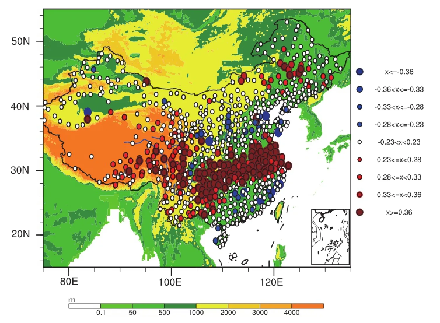
Fig.1.Correlationsbetween average rainfall(units:mm)in July and low-level cloud cover for the period 1961-2010.Color shading indicates the topography(units:m).The red and blue solid circles indicate stationsexceeding the90%confidence level(R>0.23 or R<-0.23).
4.Heavy rainfall over the YRB during 11-15 July 2000
Among all heavy rainfall zones in China,there are two main zonesw ith frequentextreme heavy rainfallevents.One is themiddleand lower reachesof the YangtzeRiver,and the other is North China(Zou et al.,1987;Wang et al.,1991). Considering the dynamic and thermal e ff ects of the TP on convectivesystemsand heavy rainfalldownstream,weselect a heavy rainfall event that occurred in the Yangtze-Huaihe River Basin during 11-15 July 2000 for this study.The correspondingaccumulated precipitation from 2000 LST 11July to 2000 LST 15 July isshown in Fig.2.
We choose this event because it isa highly typicalheavy rainfall case.The distribution of daily rainfall from during 11-15 July 2000 presents an obvious banded pattern.The rainfall started from the TP,moved eastward,and finally reached themiddle and lower reaches of the YRB;and an obvious banded pattern for the rainfall was formed(figure omitted).Figure 2 also shows this typicalheavy rainfall case was characterized by two maximum rainfall centers.One was located at the junction of Sichuan,Gansu,Chongqing and Shanxiprovinces,and the otherat thatof Hubei,Henan, Jiangsu and Anhuiprovinces.Bothmaximum centershad accumulated rainfallofmore than 50mm.Compared w ith Fig. 1,we can see that theaccum ulated rainfalldistribution of this case in Fig.2 resembles the pattern of correlation between the heavy rainfall over the YRB and low-level cloud cover upstream.This further emphasizes the important role of the moving cloud system in heavy rainfalldownstream.
The rainfall in themajor regions of the YRB fluctuated during the period,w ith an increasing trend(Fig.3),and reached its peak at 2000 LST 13 July.Figure 3 also depicts the featuresof the rainfall variation during this period,especially the continuousheavy rainfall in the latter days of this period.Buthow is the rainfall related to theeastward-moving system and associated water vapor transport?In the following sections,we continue to examine the dynamic structure and characteristics of the water vapor transport associated w ith theheavy rainfallover the YRB.
5.Theheavy rainfalldownstream from the TP and the structureof the related water vapor transport
The dominant flowsassociated w ith the Indianmonsoon and South China Sea(SCS)monsoon create themajorwater vapor transport channel during summer(Zhou et al.,2005). Liu and Ding(2009)suggested that themonsoon flow from the Indian Ocean and the Pacific have significant impactson summer rainfall over China.Thewater vapor source for the rainfall in East China ismainly the SCS,followed by the Bay of Bengal(BOB)andWestPacific(Jin,1981;Shen and Huang,1981;Chen,1982).Xu and Chen(2006)further revealed that the“big-triangle”area surrounding the TP is the key region of water vapor transport resulting in the rainfall in themiddle and lower reaches of YRB.The water vapor channels in the south and eastof the TPp lay a critical role inthe rainfallof the YRB.By analyzing theheavy rainfallover the YRB in 1998,Jian and Luo(2001)argued that the variation of the strength of themeridionalmonsoon flow follows the diurnalcycleof the upwardmotion of theairover the TP. The upward motion is stronger at night,which indicates the monsoonmeridional flow is strongerandmorewater vapor is transported.
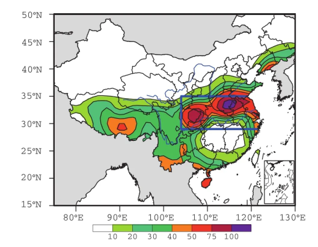
Fig.2.Accumulated rainfall(units:mm)of day 5(from 2000 LST 11 July to 2000 LST 15 July).The blue solid outline represents the key rainfall area selected in this study(29°-35°N, 104°-122°E).
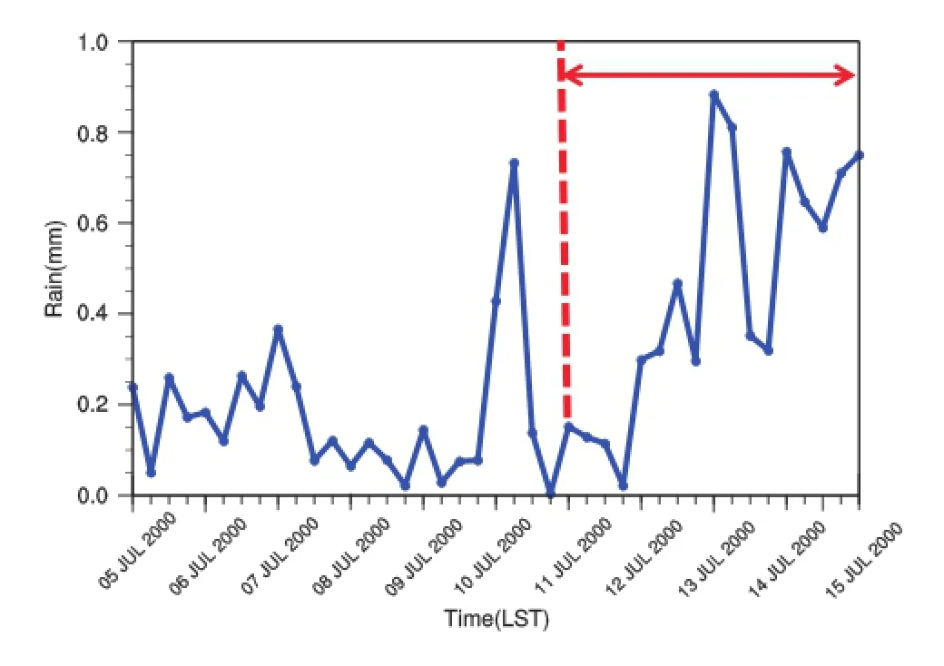
Fig.3.Time series of average rainfall(units:mm)in the key rainfallarea(29°-35°N,104°-122°E)from 2000 LST 5 July to 2000 LST 15 July(6-h interval).The red double-headed arrow indicates theheavy rainfallprocess,asshown in Fig.2.
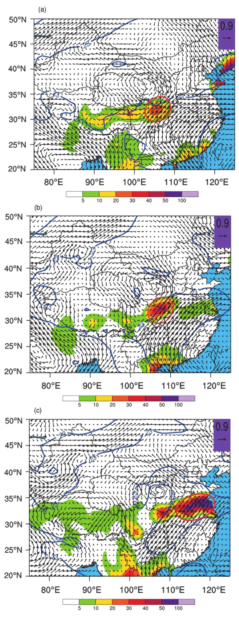
Fig.4.The(a)two-day lagged,(b)one-day lagged and(c) simultaneous correlations between the total water vapor flux (units:gm-1 s-1)and the rainfall in thekey region,represented as correlation vectors(arrows).Color-shaded areason land represent the corresponding daily rainfall(units:mm)measured at 2000 LST(a)11 July,(b)12 July and(c)13 July 2000.The blue solid lines denote the confidence levelof≥99%.The red circle indicates the precipitation area.
Know ing thata high correlation existsbetween the rainfall over the YRB and low-level convective activities,we further examine the structure ofwater vapor transportusing correlation vector analysis.In order to analyze the evolution of thewater vapor transportprior to and after thisevent, lagged correlations are calculated from 2000 LST 5 July to 2000 LST 15 July(w ith a temporal resolution of 6 hours). Figure 4a shows the lagged correlation vectors between therainfall in thekey regionsof the YRB and the totalwater vapor flux two days prior to the rainfall.It clearly shows the confluence of two water vapor channels from the SCS and the BOB,respectively.Thewatervapor transportcomes from the BOB,turns to the YRB after passing thesoutheastcorner of the TP,which approximately coincidesw ith themaximum rainfallon thesame day.Figure4b shows the lagged correlation vectorsoneday prior to the rainfall.Comparedw ith Fig. 4a,we can see that them ajor rainbandm oves eastward,and the eastern edge of the rainband even extends to them iddle and lower reaches of the Yangtze River.The sim ultaneous correlation vectors indicate that the centerofmaximum rainfallwas located in themiddle and lower reachesof the YRB at that time;thewater vaporwas transported northward from the BOB and turned to themiddle and lower reaches of the YangtzeRiveralong thenortheastern edgeof the TP.Thewater vapor starting from the SCS continuously transported the moisture to the YRB.The lagged and simultaneous correlation analysis clearly show the convergence/confluence zone of the water vapor transport,which coincidesw ith the eastwardm igration of themaximum rainfall.
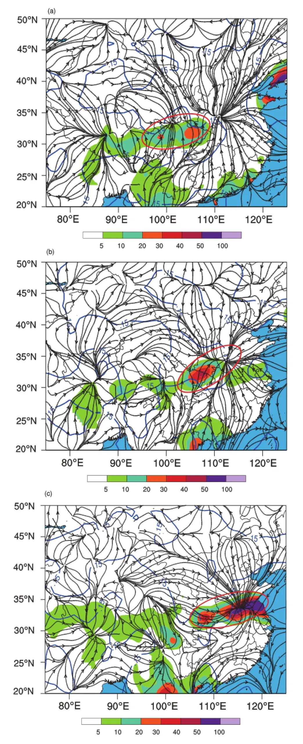
Fig.5.As in Fig.4,but for the correlations between the rainfall(units:mm)and the potential function ofwater vapor flux (units:g cm-1s-1hPa-1)at500 hPa.The blue solid linesdenote the confidence levelof≥90%.The red circle indicates the precipitation.
6.Coup led structure of “l(fā)ow level convergence-upper level divergence” in the potential function during the eastward movementof the heavy rainfall
From the perspective of eddy transport,Gao and Zhai (1993)demonstrated that theeddy transportofwater vapor is in the same direction as the gradientof thewater vapor content.Guan etal.(2011)suggested thatextreme rainfallin the middle and lower reachesof the Yangtze River is related to anomalous local circulation systems.When extreme rainfall occurs,there isusually a cyclonic circulation in themiddlelower troposphere over themiddle and lower reaches of the Yangtze River and an anticyclonic circulation to the south. We calculate the two-day and one-day lagged correlation,as well as the simultaneous correlation,between the rainfall in the major regions and the velocity potential of water vapor flux,and obtained the correspondingwater vapor flux structure(Fig.5).The two-day lagged correlationmap(Fig.5a) shows a clear water vapor convergence area in the central and eastern TP(Zone A)at 500 hPa,which coincidesw ith the east-westorientated rainband that starts from the central andeastern TPand extends to the YRB.Figure5b shows that, for theone-day lagged correlation,the areaw ithwater vapor convergence in Fig.5a hasmoved to the upper andm iddle reachesof the Yangtze River(Zone B),and coincidesw ith the heavy rainfall in HubeiProvince.Figure 5c show s the simultaneous correlation,from which it can be seen that the area w ithwater vapor flux convergence hasmoved to them iddle and lower reaches of the Yangtze River.The heavy rainfall area covers thewhole of themiddleand lower reachesof the Yangtze River and expands to Anhui,south of Henan and Jiangsu provinces.By analyzing the structureofwater vapor transport during and prior to the heavy rainfall(Figs.5a-c),we find there isalso an eastward-migrated water vapor convergence region corresponding to the eastwardm igration of the heavy rainfall.
The correlationsbetween the rainfalland velocity potentialofwatervapor flux at200 hPaand 500 hPa two daysprior to and after the rainfall are also compared,to further examine the relationship between them(Fig.6).The di ff erence between the two-day and one-day lagged correlations shows a clear divergence center of velocity potentialofwater vapor flux at200 hPa(Fig.6a),and a convergence centerat500 hPa (Fig.6b),in the centraland eastern TP.This“l(fā)ower-levelconvergenceand upper-leveldivergence”coupled system moved eastward and reached the middle and lower reaches of the YangtzeRiver,which can beeasily identified from thedi ff erence between the one-day lagged and simultaneous correlations(Figs.6c and d).
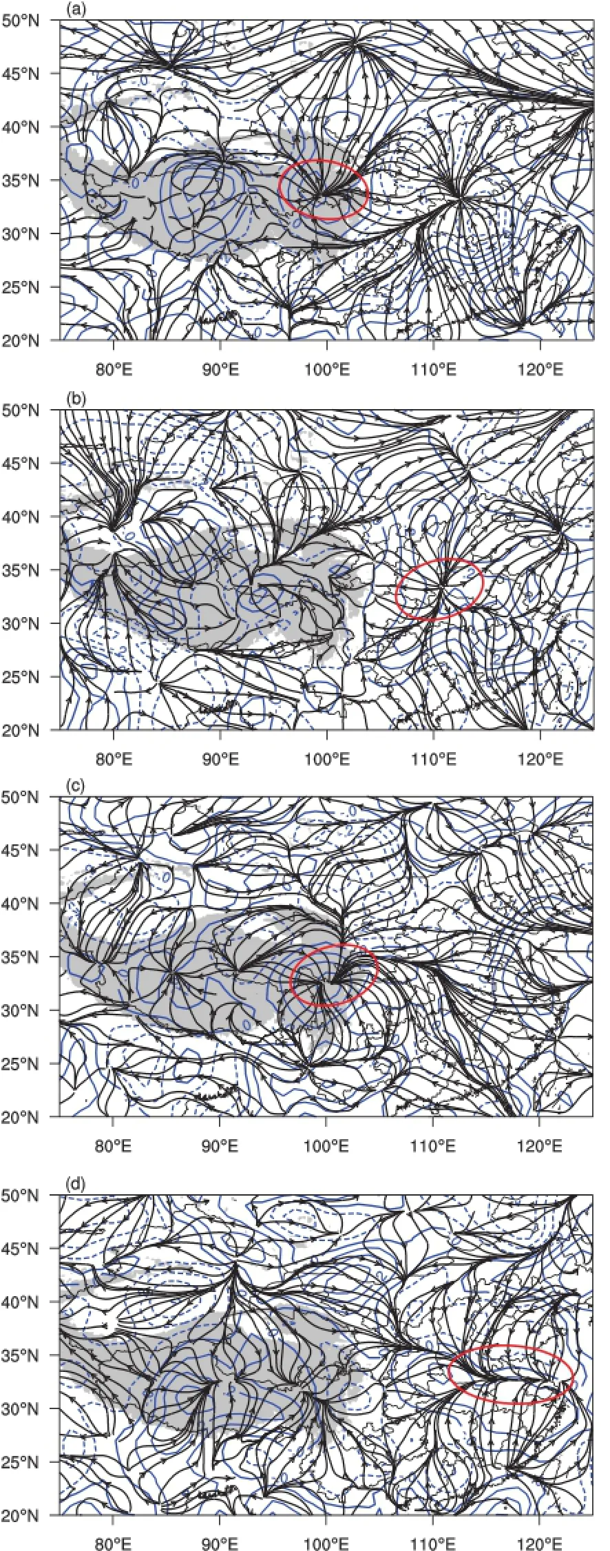
Fig.6.Di ff erences in the correlations betw een the rainfall (units:mm)in thekey rainfall region of theYRB and the potential function ofwater vapor flux(units:g cm-1s-1hPa-1)from 2000 LST 5 July to 2000 LST 15 July 2000.Di ff erences in the correlationsbetween the two-day and one-day advanced correlationsat(a)200 hPaand(c)500 hPa,and betw een theone-day advanced and simultaneous correlationsat(b)200 hPa and(d) 500 hPa.The blue lines show the di ff erence field of the correlation between two consecutive days.The solid(dashed)lines indicate positive(negative)correlation.The red circle indicates the precipitation area.
7.Dynam ic structure of eastward moving eddiesover the TP
The dynam ic and thermal e ff ectsof the TPusually result in the formation of a low pressure system over the TP.These low pressure systems,called Plateau low s,evolve into severe weather systemsand deliver abundant rainfall in downstream regions.Yu(2008)demonstrated the trem endous impacts of theeastward-moving plateau vortexeson the rainfallover the YangtzeRiverand reachesof theYellow River-HuaiheRiver. Yang etal.(2001)demonstrated that therewasa close relationship between the eastward-moving plateau vortexes and the extremeheavy rainfallover the YRB in 1998.
Given the“l(fā)ower level convergence-upper level divergence”coupled structureof theeastward-movingplateauvortex,we calculate the correlations between the rainfall in the major regionsof the YRB and the componentof the velocity potential function.
Cross-section maps(along 33°N)of correlation vectors and verticalspeed are plotted and shown in Figs.7a-d.According to the cross section of the correlation vectorsof the potential function,the area w ith upward motion(rectangular region in Fig.7a)was initially located in the central and eastern TP(98°-105°E)48 hours prior to the rainfall in the major regionsof the YRB,and the upwardmovementcenter was located in the same area.At36 hours prior to the rainfall,that areaw ith significant upwardmotion hadmoved to somewhere in the east of the TP(rectangular region in Fig. 7b).The correlation between the rainfall and vertical speed field showsapositive center in thisareabetween 500 hPaand 250 hPa.At24 hours prior to the rainfall,theupwardmotion area had partially moved out of the TP to cover an area of the plains.At12 hours prior to the rainfall,the upwardmotion had reached themiddleand lower reachesof the Yangtze River.The resultsshown in Fig.7may verify thattheaccompanying significantupwardmotionwas the dynamical cause of the heavy rainfall in themiddle and lower reaches of the Yangtze River.The above cross-sectionmaps of the velocity potential clearly depict the upward motion corresponding tothe“l(fā)ow level convergence-upper leveldivergence”coupled structure,aswell as the dynamicmechanism of generation, development and eastward movem ent of the convective systems.
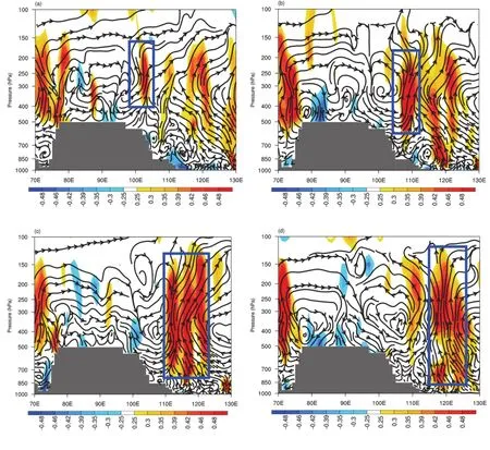
Fig.7.Correlationsbetween the rainfall(units:mm)in the key rainfall region of the YRB and the components(u,-ω)of the potential function,aswellas thecross-sectionmapsof correlationsw ith verticalmovement(-ω)(along33°N).Panels(a-d)are the cross-sectionmapsof 48-hour,36-hour,24-hourand 12-houradvanced correlations,respectively.Theblue solid rectangle represents the eastern rainfall region focused upon in this study.
8.Conclusions
In thisstudy,byanalyzing the three-dimensionalstructure of thewater vapor transport in the TP prior to aw idespread heavy rainfall eventover the YRB,we identified the“strong signals”of the dynamical and hydrological features of the synoptic systems in the TP.The resultsobtained in the study may shed some light on understanding the relationship between the heavy rainfall over the YRB and the water vapor transport and eastward-moving systems.The follow ing are themain conclusions:
(1)The convective clouds over the TP play a key role in the occurrence and development of heavy rainfall over the YRB.The results from this study reveal a close relationship between the heavy rainfall over the YRB and the eastwardmoving low-levelclouds from the TP.Thepattern of the lowlevel cloud cover coincidesw ith the distribution of the accumulated rainfallover the YRB,which also confirms its role.
(2)Lagged correlation analysis shows the existence of a“convergence”areaofwater vapor transportand itseastward movement coincidesw ith the correspondingmaximum rainfallover the YRB.
(3)A“l(fā)ower-upper level”coupled structure,represented by thevelocity potentialofwatervapor flux,originating from the TP,also plays a key role in rainfall over the YRB.This specific structural configuration is critical in leading to the occurrenceof heavy rainfalldownstream.
(4)Thestructureof thevelocity potential/stream function and the eastwardmigration of the strong upwardmotion area isalso oneof theupstream“strong signals”of heavy rainfall. The three-dimensionalwater vapor transport(flux,vorticity and divergence)prior to the occurrence of a heavy rainfall event in themiddleand lower reachesof the YangtzeRiver.
(5)By adopting themethod of three-dimensional correlation analysis between the heavy rainfall and the velocity potential/stream function ofwater vapor flux,it is possible to clearly reproduce the scenario that the eastwardmovementof water vapor transport eventually results in heavy rainfall in themiddle and lower reachesof the YangtzeRiver.Theanalyticalmethod of the velocity potential/stream function used in this paper could be adapted to a trace analysisof the generation,developmentand eastwardmovementof otherheavy rainfallormesoscale convectivesystems.
Boos,W.R.,and Z.M.Kuang,2010:Dominant control of the South Asianmonsoonby orographic insulation versusplateau heating.Nature,463(7278),218-222.
Chen,B.,X.-D.Xu,S.Yang,and W.Zhang,2012:On the origin and destinationof atmosphericmoistureand airmassover the Tibetan Plateau.Theor.Appl.Climatol.,110,423-435.
Chen,B.,X.-D.Xu,and T.L.Zhao,2013:Mainmoisture sources a ff ecting lower Yangtze River Basin in boreal summers during 2004-2009.Int.J.Climatol.,33,1035-1046.
Chen,L.X.,E.R.Reiter,and Z.Q.Feng,1985:The atmospheric heatsourceover the Tibetan Plateau:may-august1979.Mon. Wea.Rev.,113(10),1771-1790.
Chen,S.X.,1982:The definition and index of summermonsoon in the south of China.Chinese TropicalGeography,2(1),10-14.(in Chinese)
Chow,K.C.,H.W.Tong,and J.C.L.Chan,2008:Water vapor sources associated w ith the early summer precipitation over China.Climate Dyn.,30,497-517.
Gao,G.D.,and P.M.Zhai,1993:Water vapour transport during two wet/drought summers over the Yangtze river valley. Advances inWater Science,4,10-16.(in Chinese)
Guan,Z.Y.,J.Han,and M.G.Li,2011:Circulation patterns of regionalmean daily precipitation extremes and their linear trends over themiddle and lower reaches of Yangtze River during borealsummer.Climate Research,50,171-185.
Hu,G.Q.,and Y.H.Ding,2003:A study on theenergy andwater cycles over Changjiang-Huaihe river basins during the 1991 heavy rain periods.Acta Meteorologica Sinica,61(2),146-163.(in Chinese)
Jian,M.Q.,and H.B.Luo,2001:Daily variation of heatsources over the eastern Qinghai-Xizang plateau and surrounding areas and their relationship to the circulation over the Tibetan Plateau.Plateau Meteorology,21(1),25-30.(in Chinesew ith English abstract)
Jin,Z.H.,1981:Thebudgetofmoisture in the summerof 1979 in ChinaSouth Sea.The TropicalSummerMonsoon Conference. Yunnan People Press,151-164.(in Chinese)
Li,J.P.,2012:The study of characteristics,circulation situation and vapor track of low vortex on the Qinghai-Tibet Plateau. PhD dissertation,Lanzhou University,31-47.(in Chinese)
Liu,Y.Y.,and Y.H.Ding,2009:Influenceof thewestern north Pacific summermonsoon on summer rainfall over the Yangtze River Basin.Chinese JournalofAtmospheric Sciences,33(6), 1225-1237.(in Chinesew ith English abstract)
Shen,R.G.,and G.S.Huang,1981:The relation between circulation of tropicalsummermonsoon andwater vapor transport in the south of China.The Tropical Summer Monsoon Conference.Yunnan People Press,116-128.(in Chinese)
Tao,S.Y.,1980:Heavy Rainfalls in China.Science Press,225 pp. (in Chinese)
Tao,S.Y.,1987:A review of recent research on the East Asian summer monsoon in China.Monsoon Meteorology,C.P. Chang,and T.N.Krishnamuti,Eds.,Oxford University Press, 60-92.
Wang,J.Q.,S.P.Zheng,Y.Q.Cui,S.P.Xu,and W.G.Chen, 1991:An overview of the regionaldistribution ofheavy rainfall in China.Hydrology,1991(2),1-7.(in Chinese)
Wu,G.X.,and Y.S.Zhang,1998:Tibetan Plateau forcingand the timing of themonsoon onsetover south Asia and the South China Sea.Mon.Wea.Rev.,126,913-927.
Xu,X.D.,and Coauthors,2002:A comprehensive physical patternof land-airdynam icand thermalstructureon theQinghai-Xizang Plateau.Science in China Series D:Earth Sciences, 45,577-594.
Xu,X.D.,and L.S.Chen,2006:Advances of the Study on Tibetan Plateau Experiment of Atmospheric Sciences.Journal of Applied Meteorological Science,17(6),756-772.(in Chinese)
Xu,X.D.,C.G.Lu,X.H.Shi,and S.T.Gao,2008:World water tower:An atmospheric perspective.Geophys Res Lett, 35(20),doi:10.1029/2008GL035867.
Xu,X.D.,X.H.Shi,and C.G.Lu,2012:Theory and Application forWarningand PredictionofDisastrousWeather Downstream from the Tibetan Plateau.Environmental Science,Engineering and Technology Series.Nova Science Publishers, Inc.,111 pp.
Xu,X.D.,C.G.Lu,Y.H.Ding,X.H.Shi,Y.D.Guo,and W. H.Zhu,2013:W hat is the relationship between China summer precipitationand the changeof apparentheatsourceover the Tibetan Plateau.Atmospheric Science Letters,14(4),227-234.
Yanai,M.,C.F.Li,and Z.S.Song,1992:Seasonalheating of the Tibetan Plateau and its e ff ects on the evolution of the Asian summermonsoon.J.Meteor.Soc.Japan,70(1B),319-351.
Yang,K.M.,B.G.Bi,Y.A.Li,and L.Q.Dong,2001:On flood-causing Torrential Rainfall in the Upstream Districtof Changjiang River in1998.MeteorologicalMonthly,27(8),9-14.(in Chinese)
Yu,S.H.,2008:New research advances of the Tibetan plateau vortex in summer.TorrentialRain and Disasters,27(4),367-372.(in Chinese)
Zhou,Y.S.,S.T.Gao,and G.Deng,2005:A diagnostic study ofwater vapor transport and budget during heavy precipitationover theChangjiang Riverand the Huaihe Riverbasinsin 2003.Chinese Journalof Atmospheric Sciences,29(2),195-204.(in Chinese)
Zou,J.S.,M.H.Wang,andW.Zhang,1987:A preliminary study on the demarcation of rain storms in China.Acta Geographica Sinica,42(2),151-163.(in Chinese)
:Zhao,Y.,X.D.Xu,B.Chen,and Y.J.Wang,2016:The upstream“strong signals”of thewater vapor transport over the Tibetan Plateau during a heavy rainfallevent in the Yangtze River Basin.Adv.Atmos.Sci.,33(12),1343-1350,
10.1007/s00376-016-6118-7.
(Received 4May 2016;revised 10 July 2016;accepted 12 July 2016)
?Corresponding author:Xiangde XU
Email:xuxd@camscma.cn
?Institute of Atmospheric Physics/Chinese Academy ofSciences,and Science Press and Springer-Verlag Berlin Heidelberg 2016
 Advances in Atmospheric Sciences2016年12期
- Advances in Atmospheric Sciences的其它文章
- Characteristicsof the Asian-Pacif c Oscillation in Boreal Summer Simulated by BCC CSM w ith Di ff erent HorizontalResolutions
- Role of the Oceanic Channel in the Relationshipsbetween the Basin/DipoleM ode of SST Anomalies in the Tropical Indian Ocean and ENSO Transition
- Characterizing the Urban Tem perature Trend Using SeasonalUnit Root Analysis:Hong Kong from 1970 to 2015
- M odulation of TropicalCyclogenesis in theWestern North Pacif c by the Quasi-Biweekly Oscillation
- AnomalousWestern Pacif c SubtropicalHigh during Late Summer in Weak La Ni?na Years:Contrastbetween 1981 and 2013
- Simulation by CM IP5M odelsof the Atlantic M ultidecadal Oscillation and ItsClimate Im pacts